Outdoor and Travel Adventures

OTHER STUFF

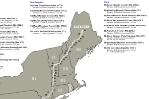
WASHINGTON STATE


Travel
Hiking & Climbing
Advice
WillhiteWeb.com
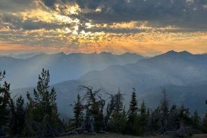
Below are trips from 2023
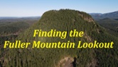
Latest Videos
392 of 429 complete
108 of 112 complete
10 of 15 complete
69 of 152 complete
Considered and Unknown Sites
47 of 82 complete
Current TOTAL for Washington
635 of 766 complete


Others


Others


58 of 58 complete


Recent Trips


Planning to get all these during my hike
National Park Fire Lookouts
Tracking down all fire lookouts that existed in our National Parks.


Two rows below are 2024 trips. Due to my Appalachian Trail hike there will be no updates until Fall.