Utah Hiking and Climbing
WillhiteWeb.com
Welcome to my Utah page where you can find everything you want to know about hiking and mountain climbing in Utah. I have got around one hundred trip reports here. I have broken Utah in 12 regions so find your intended location area and plan a trip.
Utah has 29 counties but three of the highpoints double up as two county highpoints. That leaves 26 highpoints for the state of Utah. Join the growing number of climbers and non-climbers looking to reach the highest point in every Utah county.
There are 84 peaks in Utah with 2,000+ feet of prominence. This is the list with trip reports and maps for each one as I climb them.
Trip reports for peaks that I have done in the winter. I also plan to put trips here that I did in other months but would make good winter trips based on route and access.
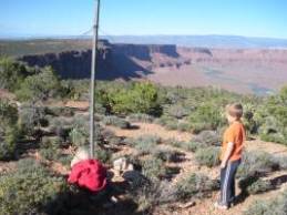
Utah is a great place to hike if you have kids. With great weather and excellent access to public lands, it offers countless trips that are quick and easy with kids.
Most of these trips are to the tops of mountains, some with trails while others are completely off trail.
These are the peaks in the Wasatch north of Interstate 80 and south of Interstate 84.
The Oquirrh Mountains are full of climbing opportunities but you need to know where to start and which routes to avoid private property. This list covers all the Oquirrh Mountain peaks with trip reports as I get to them. Antalope Island is also included here.
These mountains south of the Uintas are lower but no less beautiful in their own way. Roads will give you excellent access so the peaks are easy. Try them in fall when the colors changing on the aspens are amazing. A visit to this area will keep you coming back for more.
Check out these peaks for climbing in the winter or early spring months. The terrain is usually easy, the views are vast and you will not see another person on the summit. The weather is often sunny even when the Wasatch is socked in with clouds. Some can be reached quickly while others are really remote just to reach in your vehicle.
Located just west of Tooele, these mountains are a popular hiking destination. With lots of trails and public land, most of the peaks are easily accessible.
The Wasatch Plateau has big views and lots of easy hiking above 10,000 feet. Come here to cool off, camp and enjoy some easy peaks.
The Uinta Mountains are where most of the Utah big ones are at. Some are easy access right off the Mirror Lake Highway 50 while others require long backpacking trips to reach.
The 12 regions
These are the peaks in the Wasatch Mountains south of Interstate 80 and north of Provo Canyon. This area includes Big and Little Cottonwood Canyons, Mill Creek Canyon and American Fork Canyon. This is the most popular area for hiking in North Utah.
This area is south of Provo Canyon down to Mount Nebo.
This is a large area of Utah consisting of portions of the Wasatch Range, Monte Cristo Range and the Bear River Range.
Highlights include the Lakeside Mountains, Grassy Mountains, Newfoundland Mountains, Silver Island Mountains, Raft River Mountains and Antelope Island.


View South from Mt. Ogden


With five National Parks and many State Parks, this is just the start to a region full of hiking opportunities, known and unknown.