
George H. Hansen Peak & Four Fishes Loop
Distance: 3.5 miles (add 2 miles & 800' for low clearence vehicles)
Loop Distance: 7+ miles RT (add 4 miles for low clearence vehicles)
Elevation Gain: 3,123 for Hansen (4,340 feet for loop)
Highest Summit Elevation: 8,523 feet
Access: Rough Road
www.WillhiteWeb.com: Your online resource for hiking, climbing and travel
Access:
Route:
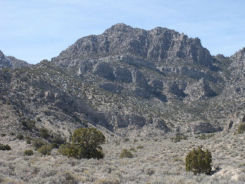
For the past 10 years, George H. Hansen Peak averages one climbing party every 2 years. This area is remote from the moment you step out of your car, be a little extra prepared for this one. George H. Hansen Peak is the highest summit in the Fish Springs Range and one of the more difficult peaks to climb in Utah. Everyone I know has had to climb at least a little class 4 rock to access the summit area. I believe there could be a route without but it has not been found yet. These mountains are very cliffy, excellent for scrambling. The traverse described below climbs the 3 highest peaks in the range. It is an interesting route that has only a few class 3 sections but enough route finding that you need to observe each peak as you approach them. The fourth summit is an easy walkup on your way up George H. Hansen Peak.


Approaching "Fish Scales"
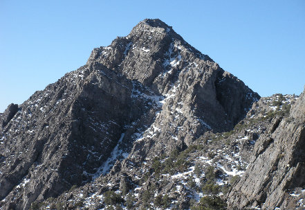
George H. Hansen Peak from "Fish Head Peak"
"Fish Head Peak" from the east

South side of "Fish Head Peak"

"Fish Head Peak", not bad looking for an un-named peak
Looking north from George H. Hansen Peak
Looking south from George H. Hansen Peak
Notch Peak
Swasey Peak
Peak 7659
"Fish Tail Peak"
"Fish Head"
"Fish Scales"
NE from George H. Hansen, Stansbury Mountains in far distance

Follow the 4WD road until you see the narrow canyon to your right, below the large cliff faces of Small Fish Peak. Walk up the canyon through fairly easy brush until the slopes look easy for climbing up Small Fish. (Skip if George H. Hansen is your only goal, continue up drainage). From the summit of Small Fish, follow the ridge lines NW over to a pass at 6,500 feet. At the pass, you are back on route. Climb up and over an exposed slide area that drops into the canyon to the north. This will put you into the next wash to follow up. At first, this wash is not too bad, gently climbing full of nice pine trees and rocks. Soon you hit a waterfall area that requires a scramble over or around. Above this, the wash is steep soon becoming talus under massive rock faces. This is the crux of the route around 7,600 feet. Of the 3 groups I know that have climbed this peak, all had a small amount of class 4 to do here yet none roped up. I think with a bit of exploring, a class 3 route could be found. I took the first gap in the rocks that looked reasonable. Once over the rocks, you enter an entire new face but much easier. Climb up this slope that is mostly brush covered until you reach what appears to be the summit. From this false summit, drop down 30 feet to a gap and climb another 200 feet or so to the real summit area. Even there, you have to scramble (3 minutes) over to the highest point where a benchmark and register await.
Follow the Pony Express Road through Fish Springs Wildlife Refuge. On the west end of the refuge, turn left on Sand Pass Road (signed). Follow this road south for 7.4 miles where the faint 4WD road turns off right. I was able to drive my 4X4 around 2.4 miles up into the canyon, almost to the point where the hike leaves the road going into the side canyon (see map).
From "Fish Head" looking down at my car, I descended via the drainage on the right
Peak 6559 "Little Fish"
Peak 7659
My truck was visible with the eye
Peak 7659
From Peak 6559 "Little Fish", a 150 degree panoramic shot of the area just after sunrise
George H. Hansen Peak
"Fish Head Peak"
"Fish Scales"
Peak 7659 from "Little Fish"
George H. Hansen from "Little Fish Peak"
Fish Springs from "Little Fish Peak"
East side of the Fish Springs Mountains rising from the desert
Climbing up the drainage to the headwall
Looking at final climb up to George H. Hansen Peak
Looking west to Ibapah and Haystack in the Deep Creek Range
Approaching "Fish Head Peak"
To do the ridge traverse, scramble down the south ridge, traverse around point 8,001 on the west side and work up the north ridge-but west side of Fish Head Peak. Just below the summit, cross over to the west side of the north ridge taking ledges up to the top. Descend SW ridge to saddle; start up north ridge of Fish Scales even though it looks like a cliff. You will run into a class 3 scramble to a notch (not visible until you are there). From top of notch, walk easily on the west side until reaching cliffs. Cross over ridge to east side, drop down to gap, and traverse 150 feet south until steep slopes (but no cliffs) are reached on the west side. Climb to summit. The descent route back to the car was almost perfect but there was one waterfall section that required lowering myself down two 10 foot drops.
Lots of arches around
George H. Hansen from the East