Mount McLoughlin Trail
Summit Elevation: 9,495 feet
Hiking Distance: 6 miles one-way
Elevation Gain: 4,000 feet
Access: Good gravel road
WillhiteWeb.com
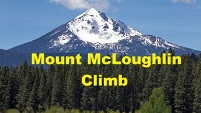
Mount McLoughlin is the major volcano that can be seen in Southern Oregon. Locally known, but go anywhere else on the west coast and nobody knows of the mountain. Although it dominates the skyline when near, the climb is a straightforward trail to the summit. A former lookout on top required the need for a trail to be built. Views on a clear day can extend south to the two California volcanos, Shasta and Lassen, and north to Crater Lake and Mt. Thielsen.
From Medford, travel East on Highway 140 or West from Klamath Falls on same highway. Three miles east of Lake of the Woods is a signed road for Four Mile Lake. On the Four Mile Lake Road is a left (possibly not signed) that goes a short distance to the well signed trailhead for McLoughlin. This is a good dirt/gravel road that any vehicle should be able to drive. The road the trailhead is on also goes out to the highway.
Just hike up the trail to the summit. After a bit of distance, the trail uses the PCT for a small segment, then veers off climbing toward the summit. You could also start at the PCT crossing of Highway 140 in early season if the Four Mile Lake Road was snowed in. Near the summit, you are above tree line and quite exposed to the elements. Inexperienced hikers tend to get themselves in trouble here. Just pay attention to where you are and follow the ridgeline to the top. This summit would probably tie with Bachelor as the easiest of the top 20 Cascade volcanoes to climb.
Access:
Route:


I took video when we were above treeline in the clouds but no photos. There was no view, just rocks and snow to see. You can find many views from the summit in good weather on other websites.
Image of McLoughlin from internet, not sure what direction