Have your phone navigate you to the paved SkyRidge North Trailhead off the Jordanelle Parkway. This area had been totally developed since I climbed the mountain so my old directions and route descriptions are no good.
You have probably driven past this minor hill many times on your way to bigger hills in the Uintas. This is just an isolated bumpl on the south side of the road between Kamas and Park City. It is surrounded on three sides by highway and the fourth side by the Jordanelle Reservoir. It makes for a nice winter snowshoe since it has good access. There is also a hiking trail to the summit.
Skyridge
Distance: Under one mile
Elevation Gain: 600 feet
Summit Elevation: 7,384 feet
Access: Paved
WillhiteWeb.com
Access:
Retreat at Jordanelle (in 2010) and the false summit above.
Jordanelle Reservoir from the flats at 7,100 feet.
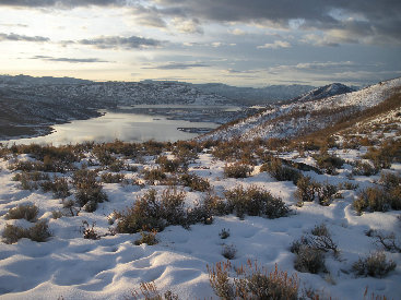
Looking south to the Jordanelle Reservoir and the Heber Valley beyond, just before sunrise. Deer Valley Resort's Bald Mountain on right.
Panoramic shot to the west looking at Deer Valley, Park City and Canyonlands Resorts peaks
Sunrise and the Jordanelle Reservoir.
Wasatch Back sub-peaks
The summit from the flats at 7,100 feet
Bald Mountain
Summit rocks, 15 minutes before sunrise


Had to wait at the summit for sunrise.
It was just getting light when I arrived on top.
Uinta Mountains

Glenco Canyon Peak
Jordanelle Reservoir


